The EO4Diversity project will focus on three Earth System Science biodiversity pilots
Pilot 1: Ecosystem productivity and health:
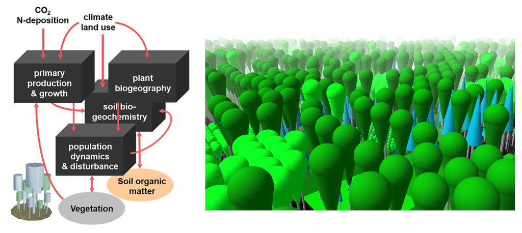
The pilot will develop an innovative integrated scientific solution that combines the scientific rigour and accuracy of RS-EBVs generated from high-resolution satellite observations on the one hand and predictive forest modelling based on LPJ-GUESS on the other. Ecosystem structural and ecosystem functional remote sensing biodiversity products for key metrics of vegetation structure and function such as species canopy cover fraction, vegetation height, forest age and LAI will constrain LPJ-GUESS for present-day and local conditions, ensuring the most realistic baseline possible for future projections. The EO-constrained model outputs of forest ecosystem structure and function will be validated using in-situ measurements and plant trait databases where applicable. LPJ-GUESS will generate spatial-temporal predictions of structural, functional and compositional variables relevant to the characterisation of forest conditions and as habitat for the biodiversity from which key ecosystem services flow. For overall validation of modelled forest productivity (i.e., GPP), as a key control on all downstream ecosystem fluxes and carbon stocks, independent flux tower-based estimates from the FLUXCOM global gridded product of ecosystem GPP will be used. As a cross-check, LPJ-GUESS outputs at the regional scale will also be compared to corresponding, well-established EO products (e.g., MODIS-NPP). To demonstrate the robustness and transferability of the integrated EO/ecosystem modelling approach, its upscaling will be performed across a pan-member state domain.

Pilot 2: Ecosystem accounting, monitoring and reporting towards policy obligations:
This pilot specifically aims to model and map EUNIS habitats at level 3- resolution across Europe by an innovative approach of integrating in situ vegetation plot data from the European Vegetation Archive (EVA) with RS-enabled EBVs and other environmental descriptors such as plant trait databases. This novel approach to operationalising the monitoring, assessment and reporting of the ecosystem condition will inform policy and decision-makers at a much higher and further improved spatial and thematic resolution level. The spatially explicit Level 3 outputs greatly facilitate the process of upscaling biodiversity data and trends. For example, the spatial Level 3 habitats can more easily link to the biodiversity and habitats trend data available through the reporting processes under the EU Habitats and Birds Directives, as well as Natura 2000 so that biodiversity patterns and trends can be more easily modelled and validated across EU. The mapping and modelling of EUNIS Level 3 habitat types innovate by combining (i) high-resolution EO data, such as RS-EBVs (e.g., LAI, phenology, vegetation height, inundation) with (ii) ESA and Copernicus high-resolution land cover data, soil and topography, (iii) high-resolution climate data from CHELSA, and (iv) more than one million in situ vegetation plots from EVA.
Pilot 3: Ecosystem resilience to invasive species:
Pilot 3 will focus on several animal IAS as well as species from the plant kingdom. Different ecological modelling approaches will be benchmarked and explored on a European scale, including deep learning techniques using collected citizen science point data (e.g., from GBIF or iNaturalist) and environmental predictor variables. These deep learning architectures will be integrated within hierarchical Point Process Models (PPMs), which describe how individual IAS observations are distributed in space. The workflow relies on environmental predictor variables drawn from state-of-the-art remote sensing variables, including land cover, phenological metrics, biophysical variables (e.g., LAI), temporal reflectance, and (potentially) backscatter metrics derived from Sentinel-2 and BD pilot 3 will focus on several animal IAS as well as species from the plant kingdom. Different ecological modelling approaches will be benchmarked and explored on a European scale, including deep learning techniques using collected citizen science point data (e.g., from GBIF or iNaturalist) and environmental predictor variables. These deep learning architectures will be integrated within hierarchical Point Process Models (PPMs), which describe how individual IAS observations are distributed in space. The workflow relies on environmental predictor variables drawn from state-of-the-art remote sensing variables, including land cover, phenological metrics, biophysical variables (e.g., LAI), temporal reflectance, and (potentially) backscatter metrics derived from Sentinel-2 and time-series data. The resulting models will finally be applied to the targeted species for selected areas of interest at both 10m and 1km resolution.
